Hurricane Polo gained 104 mph of wind in one day
NASA's satellite analysis shows the storm crossing unusually warm Pacific water before reaching Category 5 strength. Scientists caution against blaming one climate pattern for its surge.
OddBrief EditorialAI-assisted, human-reviewed
 Science
Key facts
- Fact 1
- Polo gained about 90 knots of wind in 24 hours
- Fact 2
- It reached Category 5 on September 22
- Fact 3
- Sea surface temperatures reached about 32 degrees Celsius on parts of its path
- Fact 4
- NASA cautions against assigning the intensification directly to El Niño
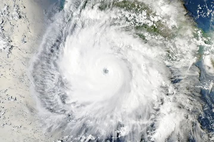
Hurricane Polo's winds increased by about 90 knots, or 104 miles per hour, in the 24 hours before it reached Category 5 strength on September 22. NASA described that extraordinary acceleration in a September 25 Earth Observatory article. Satellite images from the following day showed a large eye off Mexico's Pacific coast, with outer cloud bands extending toward land.
The ocean beneath the eye
Polo developed from a disturbance in mid-September and became a tropical storm by September 21. NASA scientists point to several ingredients that lined up during its explosive growth: weak wind shear, plentiful moisture, atmospheric instability and unusually warm water. Sea surface temperatures along parts of the path reached about 32 degrees Celsius, two to three degrees warmer than normal for September 23.
NASA's analysis paired imagery from the Aqua satellite's MODIS instrument with a sea-surface-temperature map. The map shows anomalies relative to a 2003–2014 average for that date, rather than absolute temperatures. Researchers also said warmth below the surface may have helped keep the storm supplied with energy, though the map itself only measures the surface.
By the afternoon of September 23, Polo had weakened to Category 4 as its eyewall reorganized, with maximum sustained winds around 145 miles per hour when Aqua captured the image. That is a reminder that a striking picture and a peak intensity are snapshots from different moments. Storm intensity and track can change quickly.
What the surge does not prove
NASA cited observers who placed Polo's one-day wind increase well beyond the 60-knot threshold used for extreme rapid intensification. Some analysts described it as the fastest eastern Pacific storm to move from a tropical depression to Category 5. Those records depend on definitions and complete historical estimates, so the phrasing deserves care.
Scientists quoted by NASA cautioned against attributing this one storm's acceleration directly to El Niño. Similar episodes have occurred in other Pacific conditions, and an individual event can depend on several interacting factors. The broader eastern Pacific season was unusually active as of September 24, but that is not a single-cause explanation for Polo.
NASA said forecasters expected the system to remain over the Pacific before a possible turn toward Baja California the following week. That was a forecast, not an outcome. Anyone making safety decisions needs current advisories from the National Hurricane Center and local authorities, because this article describes earlier observations.
Polo is a vivid example of how quickly a storm can exploit favorable ocean and atmosphere conditions. The satellite data help explain the episode. They do not make the next track or intensity certain.
Sources
- Explosive intensification for Hurricane PoloNASA Earth Observatoryprimary source